
Guide the next field inspection
RGB and calibrated multispectral capture can highlight differences within beds, rows or blocks. Mark areas for the agronomist to investigate; ground observations and samples establish the cause.
Adelaide Hills · McLaren Vale · Barossa · Northern Adelaide Plains
Multispectral and RGB mapping for growers, viticulturists and agronomists across Adelaide and surrounding agricultural districts. Identify variation, guide field checks and build repeat records around the decisions that matter.
Help shape a useful service
You know your farm, your clients or your project. We would like to understand where better information could save time, reduce uncertainty or help demonstrate the results of your work.
Start with a conversation. We can work out whether aerial data would add enough value to justify the scope and cost.
Whether you need a small trial, a round across several properties or extra capture capacity, tell us what a useful result would look like. We will discuss a practical starting point and agree the price before proceeding.
Two ways to work together
Growers and agronomists: use detailed imagery to locate uneven establishment, canopy variation and areas needing inspection. Nearby growers can coordinate visits to share mobilisation where practical, with the adviser defining the question and ground checks.
NRM organisations, Landcare and delivery partners: commission baseline and repeat records, agreed mapped features or additional field capture across participating properties. We can work to your specification and complement the equipment, people and data you already use.
Satellite imagery may already answer the broad question. Drone capture is worth considering where finer detail, a particular capture window or a small project footprint would change what you do next.
Agree the output before the flight
RGB and calibrated multispectral capture can highlight differences within beds, rows or blocks. Mark areas for the agronomist to investigate; ground observations and samples establish the cause.
Map visible gaps, tree or vine locations and canopy differences where resolution and visibility allow. Compare selected areas through the season. Fruit counts, disease diagnosis and yield forecasts need separate validated methods.
Document agreed fencing, watering, erosion or rehabilitation works. Repeat the footprint to show visible condition changes, with the project team setting the evidence and acceptance requirements.
Map confirmed infestations and visible cover patterns; return to assess extent or regrowth. Identification, treatment decisions and field validation remain essential.
Discuss coordinated visits, specialist capture or processing and GIS-ready delivery. We agree the sensor, positioning, formats and quality checks with your existing team.
Enquire about selected wet-ground, awkward-access or isolated treatment areas through independent network businesses. Material, crop, required coverage, authorisations and operator availability must suit the task.
Regional starting points
Our Adelaide-area and Mylor pilot-network bases provide a starting point for regional assignments, including access to viticultural and multispectral experience. We match equipment and people to the brief. Distance, property access and coordinated visits determine the practical scope and cost.
| District | Crop or land use | A useful starting question |
|---|---|---|
| Adelaide Hills | Apples, pears, cherries, strawberries and wine grapes | Which trees, rows or blocks would benefit from closer inspection, and could repeat canopy records help assess a management change? |
| McLaren Vale & surrounding Fleurieu districts | Vineyards and suitable horticultural or mixed-farm projects | Would vine-vigour zones, visible gaps or comparisons between management blocks help plan ground sampling? |
| Barossa & Eden Valley | Vineyards | Where would consistent, repeat imagery add detail to the viticulturist’s existing records and observations? |
| Northern Adelaide Plains — Virginia, Two Wells & surrounds | Outdoor vegetables and other horticulture; protected cropping assessed separately | Could establishment or canopy-variation maps help direct inspections across outdoor beds and blocks? |
| Clare Valley | Vineyards and selected surrounding agricultural projects | Is there a substantial assignment or coordinated group of properties that would justify a regional visit? |
| Riverland — by separate arrangement | Table grapes, citrus, almonds and wine grapes | Could a planned monitoring round or defined project justify travel and repeat capture? This is a separate service district, not a nearby Adelaide base. |
South Australia’s Riverland is a recognised table-grape production district. We welcome enquiries about other grape crops wherever they are grown, with the capture plan matched to the variety, trellis and management question. Regional enquiries are welcome; repeat visits and travel are quoted for the actual property.
Make the map earn its place
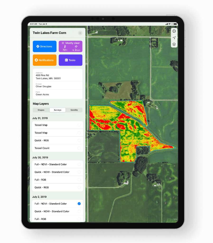
Different causes can produce similar spectral patterns. Combine imagery with irrigation records, soil and plant tests, crop history and field inspection before changing management.
Consistent timing, calibration and processing matter for comparisons. Differences in lighting, soil exposure, canopy stage and recent weather can change the appearance of a map.
We agree what can be measured reliably and how the result will be checked. Drone imagery alone does not measure soil carbon, prove reduced nutrient loss or establish a credit entitlement.
When to enquire
This is an indicative monitoring and application-enquiry guide. The same month can mean different crop stages on different properties. Your adviser and operator confirm the task and timing.
| Crop or task | Useful monitoring window | Possible application window | What to check first |
|---|---|---|---|
| Wine & table grapes | During the leafy growing season, at a canopy stage agreed with the adviser. Repeat at comparable stages; plan ahead of sampling or management decisions. | Only following a confirmed need, with a suitable product, permitted method and demonstrated coverage. | Separate vine canopy from inter-row vegetation. Imagery alone does not establish fruit quality, ripeness, disease or irrigation requirements. |
| Apples & pears | Once there is enough leaf canopy for the intended comparison; around irrigation investigations or a defined canopy-management trial. | Target- and crop-specific; assess required coverage of inner and lower foliage before proposing aerial treatment. | Netting can obscure the canopy. Do not infer fruit counts, yield or nutritional causes from a vegetation index alone. |
| Cherries & other orchard fruit | At agreed establishment and leafy-season stages; before a planned intervention and at a comparable follow-up stage. | Subject to crop sensitivity, harvest timing, permitted use and the required deposition. | Assess netting, short decision windows and access. Fruit damage and disease need appropriate field inspection. |
| Outdoor vegetables | After emergence or transplant establishment; then at crop stages chosen to investigate uneven growth or compare treatments. | When field scouting and the adviser identify a need; check aerial directions, withholding periods and crop stage. | Resolve beds or rows clearly; account for exposed soil. Check nearby people, sensitive crops and property access. |
| Strawberries & other berries | After establishment and at agreed comparable growth stages; selected irrigation or treatment comparisons. | Only where the crop, production system and application requirements suit the method. | Tunnels, netting and protected structures can limit or rule out useful aerial capture and spraying. |
| Pasture, inter-rows & selected spreading | Before renovation or an agreed trial, then after establishment or at matched seasonal stages. | Seed or suitable granular material only when the species, soil moisture, seedbed and application method suit. | Broadcast seed needs suitable soil contact and follow-up conditions. Conventional equipment may be more economical. |
| Weed patches & difficult-access areas | When target plants can be identified reliably; revisit after treatment at an interval appropriate to the species. | Following ground identification and an adviser-led plan, when plant condition and the permitted treatment method suit. | Mapping does not prove drone spraying is suitable. Woody weeds may need ground treatment; protect neighbouring crops and waterways. |
| Land-management works & trials | Baseline before intervention, then at completion and agreed recovery or reporting stages. | Any seeding, spreading or treatment is separately scoped with the responsible project team. | Agree repeat footprints, positioning, field measurements and acceptance criteria before the first flight. |
Monitoring can guide treatment; it does not prescribe it. Any spray job must satisfy the applicable label or permit, including aerial-use directions, water volume, spray quality, buffers and withholding requirements. Suitably authorised independent operators assess and conduct applications. High-volume spreading or large straightforward areas may be better served by conventional equipment.
A coordinated service
One small property may not justify a dedicated mobilisation. A round planned with an agronomist, viticulturist or grower group may make repeat monitoring more practical. Agree the useful decision window first, then group nearby visits where conditions allow.
Growers & advisers
Tell us what already works, what is difficult to see or document, and what you would do differently with better evidence. A small, agreed trial lets everyone assess usefulness before committing to a seasonal program.
NRM & Landcare teams
We can discuss additional capture across participating properties, consistent before-and-after records and GIS-ready delivery. If your organisation already operates drones, we start with the gaps in capacity or outputs rather than duplicating work.
Local conversations
Grower associations, viticultural advisers and the Hills and Fleurieu Landscape Board are useful starting points for understanding local priorities. Any funded-project capture needs an agreed specification and budget; eligibility is determined by the relevant program.
Spraying & spreading enquiries
We can explore suitable assignments through our wider pilot network. Local availability of an application operator is confirmed per enquiry. We do not assume a mapping pilot also provides spraying, or that an aircraft is a substitute for your existing orchard sprayer.
Aspex is independent of the organisations referenced here. Property data remains separate unless sharing is agreed. We confirm deliverables, permissions, equipment, operator availability and price before a job proceeds.
From question to usable records
Share the uncertainty, current records and the consequence of leaving it unresolved.
Choose timing, sensor, positioning, ground checks, file formats and a sensible budget.
Plan access and suitable conditions; combine nearby visits where practical and keep property data separate unless sharing is agreed.
Deliver to the adviser or project team, assess whether the data helps, then refine or repeat where justified.
Regional crop examples were reviewed in November 2026. The monitoring table is a planning guide based on crop stages, not a local spray calendar or agronomic prescription. Discuss actual timing with your adviser.
Images are illustrative, not records of local assignments. Crop mapping does not itself diagnose disease, measure soil carbon or verify a funding or credit claim. Application enquiries are assessed by suitably authorised independent operators against applicable aviation, chemical-use and site requirements.
Growers · Agronomists · NRM & Landcare teams
What decision needs support? What do you already know? Tell us the additional detail, timing and outputs that would make a service worthwhile. We will help assess a practical scope and cost.