
Orthomosaic mapping
A current, georeferenced site image for planning, inspection, mark-up, communication and comparison over time.
Precision Drone Mapping & Measurement
Aspex turns aerial capture into orthomosaics, terrain models, point clouds, contours, quantities and CAD/GIS-ready spatial data — so project teams can plan, measure and verify from a common evidence base.
The real product is certainty
Projects often accumulate photographs, survey files, spreadsheets and contractor reports that describe the same site in different ways. That slows decisions and creates arguments about what changed, how much material moved and which dataset is current.
Aspex creates repeatable aerial datasets that can be measured, compared and shared. The result is not simply an attractive image — it is a spatial record that supports planning, quantities, progress verification and technical discussion.
One site. One coordinate framework. Fewer assumptions.
Choose the output that answers the question
We structure capture and processing around the required output, accuracy, coordinate system and downstream software — not around a one-size-fits-all flight plan.
A current, georeferenced site image for planning, inspection, mark-up, communication and comparison over time.
DSM, DTM and elevation surfaces for drainage, earthworks, landform understanding and engineering workflows.
Dense spatial datasets for measurement, design context, digital modelling and integration into CAD or GIS environments.
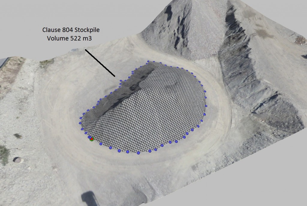
Stockpile volumes, cut/fill assessment and repeat measurements that help teams understand how much material is present or has moved.
Deliverables prepared for the software your project team already uses, including DXF, SHP, GeoTIFF, LAS/LAZ and related formats.
Compare captures from different dates to see progress, earthworks movement, changing site conditions and emerging discrepancies.
Where mapping earns its keep
Construction & civil works
Repeat mapping provides an independent project record for progress, earthworks, site logistics, quantities and issue investigation.
Mining & quarrying
Drone capture can rapidly document stockpiles, benches, haul areas and changing landform for operational measurement and planning.
Land & environmental projects
High-resolution mapping supports land development, corridor studies, environmental assessment, vegetation mapping and site planning.
Renewable energy & infrastructure
Mapping can support solar, wind, powerline and major-project workflows from baseline capture through construction and handover.

Accuracy matched to the job
Aspex uses RTK and PPK-capable systems and can incorporate ground control, checkpoints and appropriate coordinate-reference workflows where the project requires them.
Accuracy requirements differ. A progress orthomosaic, a stockpile volume, an engineering surface and a cadastral boundary are not the same task. We define the required outcome before capture and structure the workflow accordingly.
A controlled mapping workflow
Required accuracy, outputs, coordinate system, site constraints and intended use.
Repeatable flight planning using the aircraft and positioning workflow suited to the site.
Photogrammetry, georeferencing, surface generation, point-cloud processing and quality checks.
Volumes, areas, distances, contours, change and other project-specific analysis.
Outputs structured for project teams, CAD, GIS, reporting or further engineering analysis.
Deliverables that fit your workflow
Start with the decision you need to make
Tell us the site location, approximate area, required deliverables, accuracy expectations and how the data will be used. We will recommend the capture and processing workflow that fits the job.
Request a Mapping Quote