
Guide the next field inspection
RGB and calibrated multispectral capture can highlight differences within beds, rows or blocks. Mark areas for the agronomist to investigate; ground observations and samples establish the cause.
Lockyer Valley, Eastern Darling Downs & surrounding regions
Detailed crop monitoring and repeat aerial records for growers, agronomists and land-management teams. Planned around the question you need answered, with capture coordinated from our Ipswich pilot-network base.
Help shape a useful service
You know your farm, your clients or your project. We would like to understand where better information could save time, reduce uncertainty or help demonstrate the results of your work.
Start with a conversation. We can work out whether aerial data would add enough value to justify the scope and cost.
Whether you need a small trial, a round across several properties or extra capture capacity, tell us what a useful result would look like. We will discuss a practical starting point and agree the price before proceeding.
Two ways to work together
Growers and agronomists: use detailed imagery to locate uneven establishment, canopy variation and areas needing inspection. Nearby growers can coordinate visits to share mobilisation where practical, with the adviser defining the question and ground checks.
NRM organisations, Landcare and delivery partners: commission baseline and repeat records, agreed mapped features or additional field capture across participating properties. We can work to your specification and complement the equipment, people and data you already use.
Satellite imagery may already answer the broad question. Drone capture is worth considering where finer detail, a particular capture window or a small project footprint would change what you do next.
Agree the output before the flight
RGB and calibrated multispectral capture can highlight differences within beds, rows or blocks. Mark areas for the agronomist to investigate; ground observations and samples establish the cause.
Map visible gaps, tree or vine locations and canopy differences where resolution and visibility allow. Compare selected areas through the season. Fruit counts, disease diagnosis and yield forecasts need separate validated methods.
Document agreed fencing, watering, erosion or rehabilitation works. Repeat the footprint to show visible condition changes, with the project team setting the evidence and acceptance requirements.
Map confirmed infestations and visible cover patterns; return to assess extent or regrowth. Identification, treatment decisions and field validation remain essential.
Discuss coordinated visits, specialist capture or processing and GIS-ready delivery. We agree the sensor, positioning, formats and quality checks with your existing team.
Enquire about selected wet-ground, awkward-access or isolated treatment areas through independent network businesses. Material, crop, required coverage, authorisations and operator availability must suit the task.
Regional starting points
Our Ipswich base provides a starting point for jobs across nearby districts. Property location, travel, access and the number of participating growers determine the practical service area and cost.
| District | Crop or land use | A useful starting question |
|---|---|---|
| Lockyer Valley | Vegetables and leafy crops | Would detailed establishment or canopy records help direct inspections across several nearby growers? |
| Kalbar, Boonah & Fassifern | Carrots, onions, beans and pumpkins | Where do uneven establishment, irrigation patterns or trial differences deserve closer investigation? |
| Cambooya & Clifton | Leafy-vegetable production | Could an adviser-led monitoring round follow useful crop stages and the grower’s seasonal production? |
| Stanthorpe & Granite Belt | Apples, other orchard fruit, grapes, berries and vegetables | Which trees, rows or management zones need inspection, and would a repeat record help assess a change? |
| Blackbutt & South Burnett | Avocados; vineyards, macadamias and other crops across the wider region | Could canopy variation maps and targeted field checks improve the way you investigate uneven orchard performance? |
| Sunshine Coast & hinterland | Strawberries, pineapples, macadamias, nurseries and other horticulture | Is there a substantial job or group of nearby properties that makes a monitoring visit worthwhile? |
| Eastern Darling Downs & Condamine districts | Mixed cropping, pasture, riparian land and on-farm improvement sites | What needs documenting before works, after treatment or at the next agreed reporting stage? |
We assess travel for the actual property rather than promising a fixed-radius service. These districts cross several NRM regions; program boundaries and eligibility must be checked separately. For Western Downs applications, see our Chinchilla agriculture page.
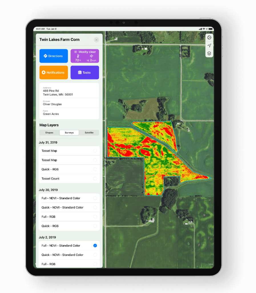
Make the map earn its place
Different causes can produce similar spectral patterns. Combine imagery with irrigation records, soil and plant tests, crop history and field inspection before changing management.
Consistent timing, calibration and processing matter for comparisons. Differences in lighting, soil exposure, canopy stage and recent weather can change the appearance of a map.
We agree what can be measured reliably and how the result will be checked. Drone imagery alone does not measure soil carbon, prove reduced nutrient loss or establish a credit entitlement.
When to enquire
This is an indicative monitoring and application-enquiry guide. The same month can mean different crop stages on different properties. Your adviser and operator confirm the task and timing.
| Crop or task | Useful monitoring window | Possible application window | What to check first |
|---|---|---|---|
| Vegetables & leafy crops | After emergence or transplant establishment; then at agreed growth stages and when uneven growth develops. | Only when scouting confirms a need and the crop stage, product and aerial-use conditions permit it. | Resolve plants or rows clearly. Check soil background, pest thresholds, crop sensitivity, harvest timing and required coverage. |
| Avocado orchards | At comparable canopy stages and during irrigation-demand periods; Queensland guidance highlights August–April as particularly important for irrigation. | Following an adviser’s recommendation and a separate assessment of canopy coverage and the permitted method. | Use soil-moisture records and ground checks. Imagery does not distinguish water stress from root disease on its own. |
| Apples, stone fruit & other orchards | Once canopy is sufficient for the intended comparison; repeat at comparable growth stages or around a planned canopy-management trial. | Crop- and target-specific, following assessment of the product and the coverage needed throughout the canopy. | Aerial spraying is not a direct substitute for an air-blast sprayer. Do not assume lower or inner foliage receives adequate coverage. |
| Vineyards | During the leafy growing season at a stage agreed with the viticulturist; use comparable stages for repeat vigour mapping. | Only where crop, target, product and application method suit. Assess canopy penetration and nearby sensitive areas. | Separate vine canopy from inter-row vegetation. Irrigation decisions require field measurements and interpretation. |
| Berries, pineapples & nursery blocks | Establishment, agreed canopy stages and selected treatment or irrigation comparisons. | After a confirmed need, subject to permitted use, coverage, crop stage and pre-harvest requirements. | Protected crops, netting, structures, people and site access can limit capture or rule out aerial application. |
| Pasture renovation & selected spreading | Before renovation, after establishment and at agreed grazing or seasonal comparison points. | Seed or suitable granular spreading in a window chosen for the species, moisture and establishment method. | Broadcast seed still needs a suitable seedbed, soil contact and follow-up conditions. A map alone does not establish feed quantity or quality. |
| Summer grass weeds & parthenium | Inspect after germinating rain; plan ahead of spring and summer flushes and check for further emergence. | Assess young, actively growing plants before seed set, using a species- and situation-appropriate method. | Confirm species and resistance history. Some crop situations have limited options; treatment may be by ground equipment. |
| Fleabane | Winter–spring, pre-plant and during or immediately after the winter-crop phase. | Plan control of small plants before they become large or moisture-stressed; use adviser-selected tactics. | Do not wait for summer by default. Crop competition, residuals and non-chemical methods may be part of the plan. |
| Mother-of-millions | Often easiest to locate in flower, generally May–October; assess control at other times too. | Subject to suitable plant condition, coverage and the applicable permitted method. | Toxic to stock. Ground treatment may be more appropriate; inspection timing does not establish drone suitability. |
| African boxthorn | Map confirmed infestations; assess foliar control during active growth, often February–May. | Possibly not suitable for drone spraying; often better treated on the ground. | Thorough foliar coverage or basal-bark/cut-stump methods may be needed. Avoid hot, dry or stressed foliar-treatment conditions. |
| Riparian, erosion & rehabilitation works | Before works; at completion; then at agreed recovery or reporting stages. Add post-event capture only when safe and useful. | Any revegetation, spreading or weed treatment is separately scoped with the project manager. | Use matching footprints and positioning. Surface-model change needs suitable accuracy checks; vegetation can obscure the ground. |
| Demonstration plots & funded trials | Baseline before intervention; repeat on dates and crop stages agreed in the monitoring plan. | Applications follow the trial design and responsible adviser’s instructions. | Agree controls, sampling, weather records, outputs and acceptance requirements before capture. |
Monitoring can guide treatment; it does not prescribe it. Any spray job must satisfy the applicable label or permit, including aerial-use directions, water volume, spray quality, buffers and withholding requirements. Suitably authorised independent operators assess and conduct applications. High-volume spreading or large straightforward areas may be better served by conventional equipment.
Public programs & local conversations
Program information reviewed 1 November 2026. These examples show where aerial evidence could fit. Discuss current priorities, eligibility, reporting requirements and any monitoring budget with the delivery organisation.
Southern Queensland Landscapes
The published program supports pasture and grazing improvements, groundcover, infiltration and demonstrations. Potential capture tasks include selected paddock baselines, repeat cover records and documentation of agreed management changes.
Southern Queensland Landscapes
The published project supports eligible commercial graziers with fencing, off-stream watering and grazing improvements in priority catchments. Its page specifies approved on-ground works completed by 30 June 2027. Baseline and follow-up site records could be scoped where the program requires them.
Supporting existing expertise
SQ Landscapes leads field operations for the Queensland south soil-monitoring cluster and has delivered drone capability-building through Wandhala. We would first ask whether additional site context, specialist capture or processing would complement existing work. Physical soil sampling remains essential.
Soil monitoring · Wandhala project · Sustainable Agriculture Facilitator
North East Downs Landcare
Documented 2026 activities include a workshop on prickly-pear biological control and the Condamine grazing program, and partner-supported drone flyovers of local reserves. Repeat site records, confirmed weed-patch maps or participating-property visits may be worth discussing.
Contact the group about current landholder priorities and whether consistent follow-up imagery would support its work. Any service would be scoped with the group and participating landholders.
Aspex is independent of these organisations and programs. We can supply agreed evidence; the grower, adviser or project team determines how it is interpreted and whether it meets reporting requirements. Funding approval, soil-carbon measurement and credit verification are not implied.
From question to usable records
Share the uncertainty, current records and the consequence of leaving it unresolved.
Choose timing, sensor, positioning, ground checks, file formats and a sensible budget.
Plan access and suitable conditions; combine nearby visits where practical and keep property data separate unless sharing is agreed.
Deliver to the adviser or project team, assess whether the data helps, then refine or repeat where justified.
The regional examples and planning windows draw on the sources below. Crop stages and site conditions govern the actual capture plan; the table is not an agronomic prescription.
Vineyard and application imagery is illustrative, not a record of a particular local assignment. Services depend on suitable equipment, operator availability, permissions and an agreed scope.
Growers · Agronomists · NRM & Landcare teams
What decision needs support? What do you already know? Tell us the additional detail, timing and outputs that would make a service worthwhile. We will help assess a practical scope and cost.